
Above ground flows represent a dynamic and vital component of the drainage basin system. These flows, including throughfall, stemflow, overland flow, and channel flow, play a key role in shaping the hydrological cycle. Understanding these processes is crucial for A-Level Geography students, as it provides insights into the movement of water through various landscapes and its impact on the environment.
Throughfall
Throughfall is the process where precipitation passes through gaps in the vegetation canopy or drips off leaves and branches, reaching the ground.
- Nature of Throughfall:
- It varies depending on the density and type of vegetation, season, and the intensity of rainfall.
- In dense forests, a significant portion of rainfall is intercepted by the canopy, altering the pattern and amount of throughfall.
- Impact on Hydrological Processes:
- Water Distribution: It plays a crucial role in redistributing water across different parts of the forest floor.
- Soil Moisture: Influences soil moisture levels, which is vital for plant growth and groundwater recharge.
- Surface Runoff: Can contribute to surface runoff, especially during intense rainfall events.
Stemflow
Stemflow is the movement of water down the stems and trunks of plants and trees, an important component of the water cycle in forested areas.
- Mechanism of Stemflow:
- Begins with water interception by foliage, then channels along twigs and branches, converging towards the main stem or trunk.
- Affected by the architecture of the plant, including leaf shape and branch angle.
- Contribution to Soil Water:
- Provides a concentrated input of water directly to the base of the plant, which can be beneficial in dry conditions.
- Influences soil moisture heterogeneity, affecting plant and microbial communities near the base.
Overland Flow
Overland flow, also known as surface runoff, is the flow of water that occurs when excess stormwater, meltwater, or other sources flows over the Earth's surface.
- Hortonian Overland Flow:
- Named after Robert E. Horton, it occurs when the rainfall rate exceeds the soil's infiltration capacity.
- Common in urban areas with impervious surfaces and in arid regions with hard, compacted soils.
- Saturation Overland Flow:
- Occurs in areas where the soil is already saturated and cannot absorb more water.
- Typical in wetter climates and areas with high water tables.
- Factors Influencing Occurrence:
- Soil Characteristics: Texture, structure, and organic matter content play a significant role.
- Land Use: Urbanization increases impervious surfaces, enhancing runoff.
- Climate: Rainfall intensity and duration are key determinants.
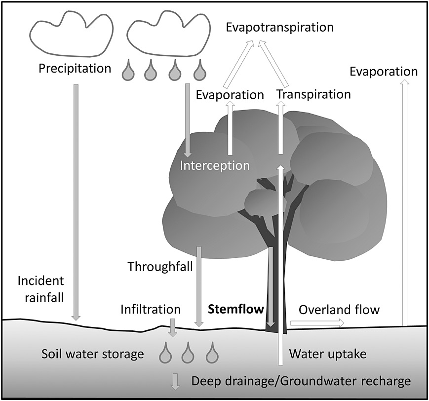
Image courtesy of agupubs.onlinelibrary.wiley.com
Channel Flow
Channel flow is the movement of water within a river or stream channel, a critical aspect of fluvial geomorphology.
- Laminar vs. Turbulent Flow:
- Laminar flow, characterized by layers of water sliding smoothly over each other, is rare in natural channels.
- Turbulent flow, with chaotic, swirling currents, is more common and greatly influences erosion and sediment transport.
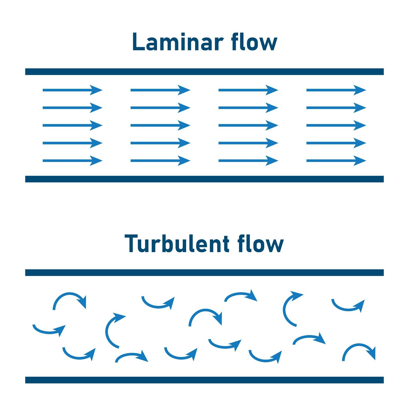
Image courtesy of SAMYA
- Factors Affecting Flow:
- Channel Characteristics: Size, shape, and roughness of the channel bed and banks affect flow velocity and patterns.
- Gradient: The slope of the river channel influences the speed of the flow.
- Discharge: The volume of water passing a point per unit time, determined by factors like rainfall, snowmelt, and upstream water use.
FAQ
Different soil types have varying effects on infiltration rates, which in turn influence the occurrence of overland flow. Sandy soils, with large particle sizes and high porosity, allow rapid infiltration of water, reducing the likelihood of overland flow. On the contrary, clayey soils, characterized by small particle sizes and low porosity, have slower infiltration rates, making them more prone to overland flow during heavy rainfall. Loamy soils, which are a mixture of sand, silt, and clay, typically have moderate infiltration rates and are less susceptible to overland flow compared to clayey soils. Soil structure, organic matter content, and the presence of a soil crust also affect infiltration. Compacted soils and soils with a crust have reduced infiltration rates, increasing the risk of overland flow. Therefore, soil management practices that maintain soil structure and prevent compaction are essential for managing overland flow.
Vegetation plays a crucial role in influencing the occurrence and effects of overland flow. It increases the soil's capacity to absorb water through root systems, which create pores and channels in the soil, enhancing infiltration. The presence of vegetation also slows down the velocity of overland flow, reducing soil erosion. Plants and trees intercept rainfall, reducing the volume of water that reaches the ground and thereby decreasing the potential for overland flow. Vegetative cover also acts as a natural filter, trapping sediments and pollutants carried by runoff, which helps to maintain water quality. In areas with sparse vegetation, overland flow is more likely to occur and can have more severe consequences, such as increased soil erosion and sediment transport. The management of vegetation cover is thus an important aspect of controlling and mitigating the effects of overland flow in various environments.
Changes in channel flow can have significant ecological impacts on river systems. An increase in flow velocity, often caused by heavy rainfall or snowmelt, can lead to erosion of riverbanks and the riverbed, altering the habitat for aquatic life. This can disrupt the breeding and feeding patterns of fish and other aquatic organisms. On the other hand, a decrease in flow, possibly due to droughts or upstream water extraction, can lead to reduced habitat availability and lower water quality. Lower flows can increase the concentration of pollutants and decrease oxygen levels in the water, adversely affecting aquatic ecosystems. Additionally, changes in flow patterns can influence the distribution and abundance of plant species along riverbanks and floodplains, affecting the entire riparian ecosystem. Maintaining natural flow regimes is crucial for preserving the ecological balance of river systems.
Urbanization significantly alters the patterns and impacts of overland flow due to the increase in impervious surfaces like roads, pavements, and buildings. These surfaces prevent water from infiltrating into the soil, leading to an increase in the volume and velocity of surface runoff. The rapid concentration of runoff in urban areas can overwhelm drainage systems, leading to urban flooding. Additionally, urban runoff tends to carry a variety of pollutants, including oils, heavy metals, and sediments, which can degrade water quality in rivers and streams. Urbanization also reduces the natural buffering and absorption capacity of the landscape, diminishing the ecosystem's ability to handle excess water. These changes highlight the need for effective urban planning and the implementation of sustainable urban drainage systems (SUDS), like green roofs and permeable pavements, to mitigate the adverse impacts of urbanization on overland flow.
To measure and monitor overland flow and channel flow in rivers, several methods are employed. For overland flow, techniques such as the use of runoff plots and tracer studies are common. Runoff plots are small, controlled areas where rainfall and runoff are measured to assess the volume and rate of overland flow. Tracer studies involve adding a harmless dye or isotope to the water and tracking its movement to understand flow patterns. For channel flow, stream gauges are widely used. These gauges measure the water level in a river or stream, and through established relationships between water level and flow rate, the discharge can be calculated. Additionally, velocity meters, such as propeller and acoustic Doppler velocimeters, are used to measure the speed of water flow directly. Remote sensing technologies, including satellite imagery and aerial photography, are increasingly used for larger-scale monitoring of river flows and flood events. These methods provide vital data for hydrological research, water resource management, and flood forecasting.
Practice Questions
Stemflow plays a crucial role in forested drainage basins by directing a portion of intercepted rainfall down the stems and trunks of trees directly to the base. This targeted delivery of water concentrates moisture in the vicinity of the tree, which can be vital for the tree's own water uptake, especially in drier conditions. Furthermore, stemflow significantly influences the spatial distribution of soil moisture, often leading to increased soil water content around the base of the tree. This can affect the growth of understory vegetation and the microbial activity in the soil, as these organisms rely on soil moisture. Stemflow also contributes to the cycling of nutrients, as it can transport dissolved substances from the canopy to the soil, enhancing fertility around the tree base. Overall, stemflow is an integral component of the hydrological cycle in forested areas, influencing both water and nutrient dynamics in the soil.
Hortonian overland flow occurs when the rate of rainfall exceeds the soil's infiltration capacity, leading to excess water flowing over the land surface. The key factors influencing its occurrence include soil type, land cover, and rainfall characteristics. Impermeable or compacted soils, common in urban or arid areas, have low infiltration rates, making them more prone to Hortonian overland flow. Similarly, land cover plays a significant role; urban areas with impervious surfaces like concrete and asphalt exacerbate runoff. The intensity and duration of rainfall are also crucial; intense, short-duration storms are more likely to exceed the infiltration capacity of soils. The environmental implications of Hortonian overland flow are substantial. It can lead to increased soil erosion, particularly in areas with little vegetation cover. In urban environments, it contributes to flash flooding, which can cause significant property damage and pose risks to human safety. Moreover, as runoff flows over the surface, it can pick up pollutants, leading to water quality issues in rivers and streams downstream. Understanding these factors is vital for effective water management and mitigation of the adverse environmental impacts associated with Hortonian overland flow.
