
Hydrographs are invaluable tools in river hydrology, offering insights into the dynamics of river discharge over time. Their analysis is particularly pertinent in understanding and predicting flood events. This section focuses on the essential elements of hydrographs: lag time, peak discharge, and base flow. Furthermore, it examines the influence of natural factors like geology and seasonality on hydrographs, which are vital in comprehending river system behaviours.
Understanding Hydrograph Characteristics
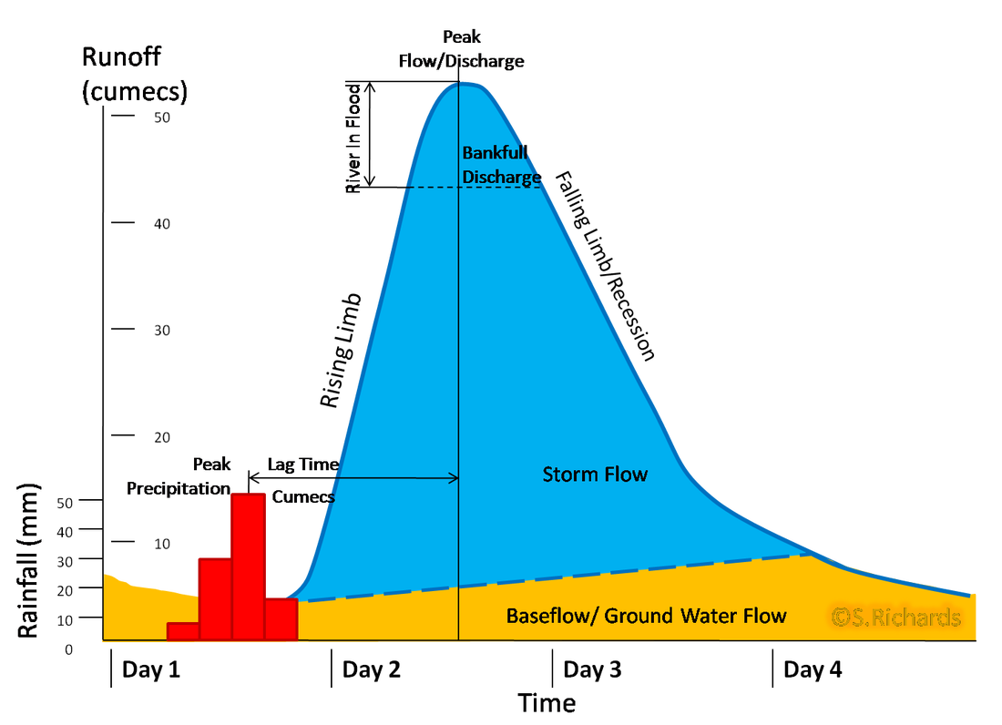
Lag Time
- Lag time is the interval between the peak of a rainfall event and the peak discharge in the river. It's a critical factor in flood management as shorter lag times can result in rapid flooding events.
- Factors influencing lag time:
- Topography: Steeper slopes in the river basin can significantly reduce lag time, leading to quicker surface runoff.
- Soil Type: Soils like clay are less permeable and can lead to faster surface runoff, reducing lag time. In contrast, sandy soils, which are more permeable, can increase lag time.
- Vegetation: Areas with dense vegetation generally have longer lag times due to increased interception and transpiration.
- Urbanisation: Urban areas, with their impermeable surfaces, facilitate quicker runoff, substantially reducing lag time.
Peak Discharge
- Peak discharge represents the maximum flow rate in the river following a precipitation event. It is a crucial indicator of potential flood risk.
- Influencing factors include:
- Rainfall Intensity and Duration: Higher intensity and longer-duration rainfall events can lead to increased peak discharge.
- Antecedent Moisture: Saturated soils from previous rainfall can contribute to higher peak discharges.
- River Channel Characteristics: Narrow or shallow channels can lead to higher peak discharges during heavy rainfall events.
- Understanding and measuring peak discharge is vital for flood forecasting and the design of flood defences.
Base Flow
- Base flow is the regular, everyday flow level of the river, primarily sustained by groundwater. It represents the river's discharge in the absence of recent rainfall.
- Factors affecting base flow include:
- Geological Conditions: Permeable rocks allow more groundwater to seep into the river, maintaining a steady base flow.
- Seasonal Variations: In drier seasons, the base flow becomes a critical component of the river's discharge, maintaining water availability for ecosystems and human use.

Image courtesy of alevelrivers.weebly.com
Natural Influences on Hydrographs
Influence of Geology
- The geological structure of a river's catchment area has profound effects on its hydrograph. Different rock types and structures influence how quickly rainwater reaches the river channel.
- Permeable substrates, like limestone or sandstone, allow more water to percolate through the ground, leading to a more moderated and delayed river response.
- Conversely, impermeable rocks, such as granite or clay, lead to rapid surface runoff, resulting in steeper rising limbs and higher peak discharges.
- Geological faults and other structures can also create pathways for water, altering the hydrograph's shape.
Seasonality and Weather Patterns
- Seasonal changes have significant impacts on hydrograph characteristics. For example, in temperate regions, winter precipitation often leads to higher base flows due to reduced evapotranspiration.
- In monsoon climates, intense seasonal rainfall can cause dramatic changes in river discharge, often leading to flooding.
- Snowmelt in spring can contribute to increased river discharge, affecting both the timing and magnitude of peak flows.
- Long-term weather patterns, such as El Niño and La Niña, influence precipitation and temperature patterns globally, thereby affecting river hydrographs.
Case Studies: Examining Real-World Hydrographs
Case Study 1: River in a Temperate Climate
- This case study analyses a river in a temperate climate zone. It illustrates how a combination of moderate rainfall, gradual snowmelt, and varied topography can influence hydrograph characteristics.
- Observations show that the lag time is typically longer, attributed to gradual rainfall and permeable geological formations.
- Seasonal changes are evident, with higher discharges in late winter and spring due to combined effects of rainfall and snowmelt.
Case Study 2: River in a Monsoon Climate
- The focus here is on a river experiencing intense seasonal monsoon rains. The resulting hydrograph characteristically shows a steep rising limb and a high peak discharge.
- The shorter lag time is due to intense rainfall over impermeable geological formations, leading to rapid runoff.
- These conditions pose significant flood risks, necessitating effective flood management and prediction strategies.
Summary and Implications
Understanding hydrograph characteristics is essential for predicting and managing flood events. By analysing factors like lag time, peak discharge, and base flow, geographers and environmental managers can develop more effective flood mitigation strategies. Additionally, comprehending the natural influences on hydrographs, such as geology and seasonality, enables a deeper understanding of the dynamics of river systems. This knowledge is pivotal for sustainable water resource management and for preparing for the impacts of climate change on hydrological cycles.
Through this detailed exploration of hydrographs, IB Geography students gain a comprehensive understanding of the complexities involved in river hydrology and flood management. This knowledge forms a critical part of their geographical education, equipping them with the skills to analyse and respond to environmental challenges.
FAQ
Antecedent moisture refers to the moisture level in the soil before a rainfall event. It can significantly impact a hydrograph, particularly the peak discharge and the shape of the rising limb. If the soil is already saturated from previous rainfall, additional rain will lead to more immediate and direct runoff into the river, potentially increasing peak discharge and reducing lag time. This condition can heighten flood risk. Conversely, if the soil is dry, it can absorb more water, reducing immediate runoff, leading to a more gradual rise in the river's discharge and a lower peak discharge.
Yes, human interventions besides urbanisation can markedly affect a river's hydrograph. Agricultural practices, for instance, influence runoff and infiltration rates. The construction of dams and reservoirs can drastically alter a river's natural flow regime, often reducing peak discharges and modifying the overall shape of the hydrograph. Afforestation or reforestation can increase lag time and decrease peak discharge due to enhanced interception and infiltration. Conversely, deforestation can lead to increased runoff and higher peak discharges. These interventions demonstrate the significant impact human activities have on river systems and their hydrological characteristics.
The size and shape of a drainage basin play a crucial role in determining the characteristics of its hydrograph. Larger basins tend to have longer lag times due to the greater distance water must travel to reach the river. Additionally, the shape of the basin impacts how quickly water is concentrated into the river. For example, circular basins tend to have quicker runoff and shorter lag times compared to elongated basins. The slope of the basin is also a factor; steeper basins usually have faster surface runoff, leading to shorter lag times and higher peak discharges.
Different types of vegetation can significantly influence a river's hydrograph by altering the lag time and potentially the peak discharge. Densely vegetated areas, particularly those with deep-rooted trees and shrubs, can increase lag time due to higher rates of interception and transpiration. This means that less precipitation directly reaches the river, leading to a slower and more moderated response in the hydrograph. Conversely, areas with sparse vegetation or dominated by short-rooted plants may have quicker runoff, reducing lag time and potentially increasing peak discharge. Vegetation cover also impacts soil erosion and infiltration rates, further influencing the hydrograph characteristics.
The rising limb of a hydrograph represents the increase in river discharge following rainfall. Its steepness indicates how quickly the river responds to precipitation, which is influenced by factors such as soil permeability and land use. A steep rising limb typically signifies rapid runoff and a potentially higher flood risk. The falling limb, on the other hand, shows the rate at which the river returns to its normal level. A prolonged falling limb indicates slower drainage and can be a sign of high groundwater levels or permeable soil, which allows for gradual infiltration and runoff.
Practice Questions
Urbanisation significantly alters a river's hydrograph by reducing lag time and increasing peak discharge. This is primarily due to the increased prevalence of impermeable surfaces, such as concrete and asphalt, which prevent water from infiltrating into the ground. Consequently, more runoff is directly channelled into rivers, leading to a quicker rise in river levels following rainfall. Additionally, urbanisation often involves modifications to natural waterways, such as canalisation, which can further expedite water flow, thus elevating the risk of flooding. Overall, urban areas typically exhibit hydrographs with steeper rising limbs and higher peak discharges compared to rural areas.
The geology of a river basin plays a pivotal role in determining its base flow. Permeable rocks, such as sandstone or limestone, allow greater infiltration of water into the ground. This infiltration replenishes groundwater stores, which in turn sustain the river's base flow, especially during periods of low precipitation. In contrast, river basins with impermeable geological formations like clay or granite have limited groundwater recharge, leading to lower base flows. Such rivers rely more heavily on direct runoff and are more susceptible to variations in rainfall. Therefore, the geological composition of a river basin is fundamental in maintaining its ecological balance and water availability.
