
River landforms are dynamic and diverse, sculpted by the interplay of erosion, transportation, and deposition. This section explores the formation of significant river landforms including waterfalls, floodplains, meanders, levees, and deltas, essential for understanding river systems in geography.
Waterfalls
Waterfalls, one of the most striking river landforms, form through distinct geomorphological processes:
- Hard and Soft Rock Interactions: Typically, waterfalls occur where a river flows over a sequence of rock layers of varying resistance. The differential erosion between harder and softer rock layers is pivotal. The softer rock erodes quicker, undermining the harder rock, creating a ledge that eventually collapses.
- Erosion and Plunge Pools: At the base of a waterfall, the falling water creates a plunge pool. Erosive processes like hydraulic action (water forcing its way into cracks) and abrasion (rocks carried by the water grinding against the riverbed) deepen the plunge pool.
- Recession of the Waterfall: The continual erosion at the base and the undercutting of the hard rock layer lead to the gradual retreat of the waterfall. Over time, this process can create a steep-sided gorge.
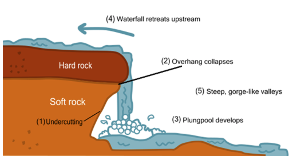
Image courtesy of alevelgeography.com
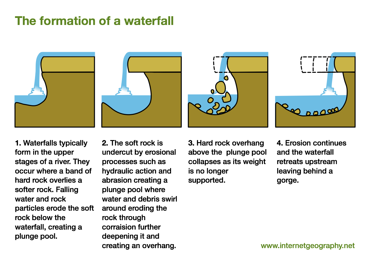
Image courtesy of alevelgeography.com
Floodplains
Floodplains are extensive, flat areas that border rivers, formed through deposition:
- Deposition During Flooding: When a river overflows, it spreads out over the floodplain. The reduction in velocity causes sediment to be deposited. The finest materials travel furthest from the river, leading to graded bedding.
- Alluvial Deposits: Floodplains are characterised by alluvial deposits – rich, fertile sediments laid down by rivers. These deposits can vary in thickness and composition, reflecting the river’s flow and sediment load history.
- Levee Formation: During floods, the heaviest materials (like gravel and sand) deposit first as the river overflows its banks. These materials gradually accumulate to form natural levees, which can rise significantly higher than the surrounding floodplain.
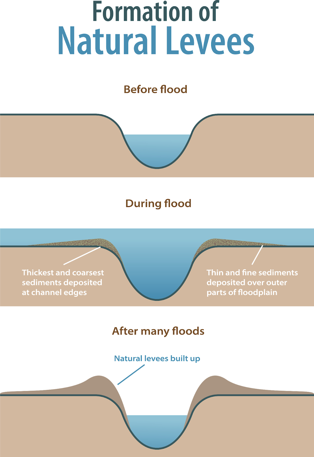
Image courtesy of zombiu26
Meanders
Meanders are sinuous, winding curves in a river, formed and maintained by erosion and deposition:
- Formation of Meanders: Meanders begin as slight bends in a straight river. Water flows faster on the outside of the bend, causing erosion (river cliff), while slower flow on the inside leads to deposition (slip-off slope).
- River Migration: The ongoing erosion and deposition cause the meanders to migrate across the floodplain. This lateral movement can be significant over time, altering the landscape dramatically.
- Oxbow Lakes: In extreme cases, meanders can become so pronounced that the river cuts through the narrow neck of land, forming a new, straighter course and leaving behind an oxbow lake.
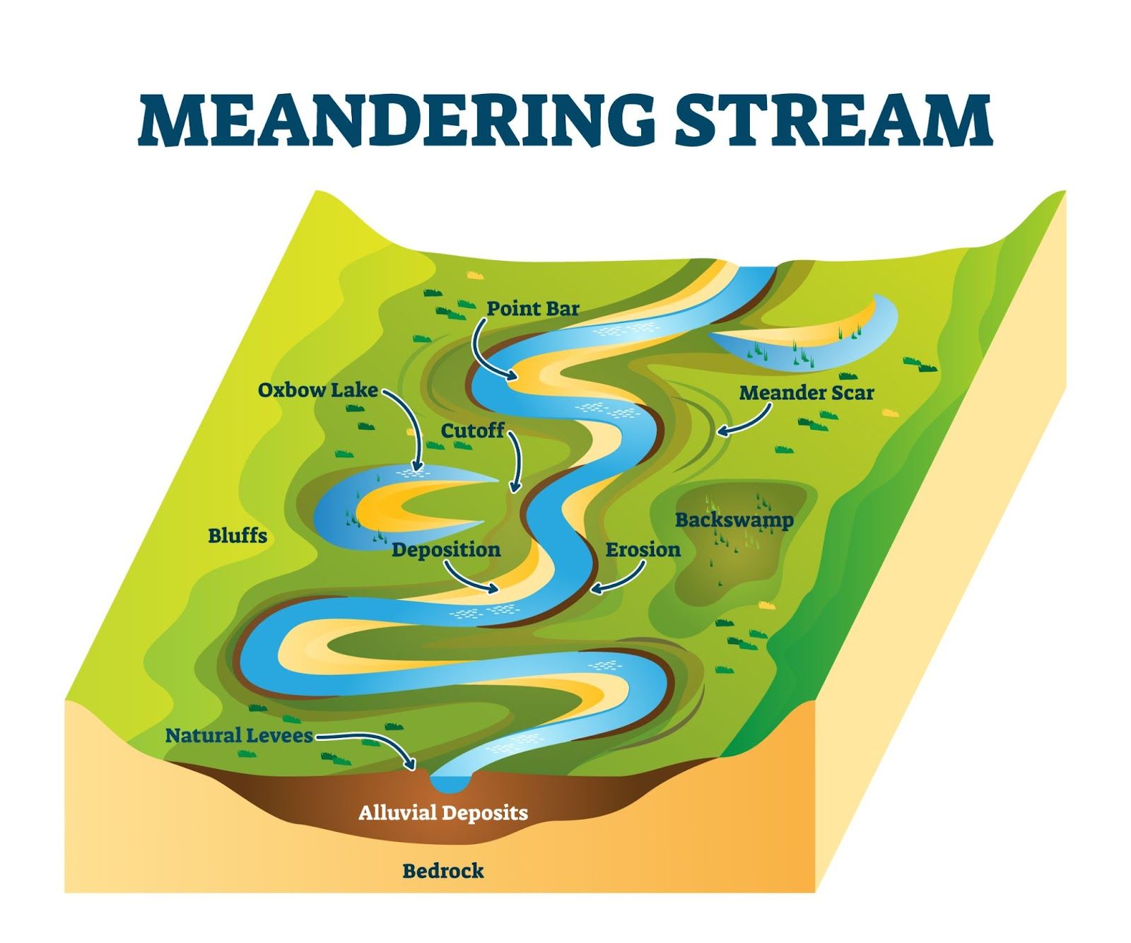
Image courtesy of VectorMine
Levees
Levees are natural embankments that form parallel to a river channel:
- Formation and Growth: As the river floods, the largest sediments are deposited closest to the river bank. These deposits build up over time, forming levees. The height and composition of levees can vary, reflecting the river’s discharge and sediment load.
- Influence on Floodplains: Levees can influence the extent and severity of flooding on adjacent floodplains. Higher levees might protect areas from smaller floods but can exacerbate flooding when overtopped.
Deltas
Deltas form at the mouth of a river as it enters a standing body of water:
- Depositional Processes: The reduction in river velocity upon meeting a larger, still body of water leads to sediment deposition. This sediment builds up, creating the deltaic landform.
- Distributaries and Delta Types: The river may split into several smaller channels, called distributaries, which distribute sediments across the delta. The shape and form of deltas (like bird’s foot, arcuate, or cuspate) depend on the interplay between sediment load, wave action, and tidal movements.
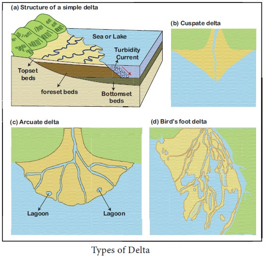
Image courtesy of drishtiias.com
- Delta Environments: These areas are dynamic and ecologically rich, often supporting diverse ecosystems. They are also important for human activities such as agriculture, due to their fertile soils.
The study of river landforms is vital for understanding the geomorphological processes that shape our landscapes. These features not only illustrate the dynamic nature of river systems but also have significant implications for environmental management and planning. By comprehending the formation and evolution of these landforms, students can appreciate the complexity and beauty of riverine environments.
FAQ
The concept of a river's changing base level – the lowest point to which a river can erode – is crucial in understanding landform development. A drop in base level, often due to sea level fall, can cause a river to erode its bed more deeply, leading to the formation of features like incised meanders and river terraces. Conversely, a rise in base level, such as from a sea level rise, can lead to increased deposition as the river's ability to carry sediment decreases. This can result in the formation of landforms such as deltas and floodplains. Changes in base level, whether due to natural processes or human activities like dam construction, can significantly alter a river's profile and the associated landforms.
An oxbow lake forms through the natural process of meandering in river systems. Over time, the outer banks of a meander, where the river flow is faster, undergo erosion, while the inner banks experience deposition. This process gradually exaggerates the bends in the river. During periods of high flow or through gradual erosion, the river may cut through the narrow neck of a meander, forming a new, straighter channel. The abandoned meander loop, now cut off from the main river, forms an oxbow lake. These lakes are typically crescent-shaped and can be temporary, as they may eventually fill with sediment and vegetation.
Floodplains play a crucial role in a river's ecosystem. They act as natural flood management systems by absorbing and slowly releasing floodwaters, reducing the risk and severity of floods downstream. The sediments deposited on floodplains during flooding are typically rich in nutrients, making these areas highly fertile and important for agriculture. Floodplains also support diverse habitats for a wide range of species, both aquatic and terrestrial. They provide spawning grounds for fish, habitat for birds, and grazing land for mammals. The interaction between the river and its floodplain is vital for maintaining the health and biodiversity of riverine ecosystems.
River deltas evolve through a continuous cycle of sediment deposition and reworking by river, ocean, and tidal currents. Initially, a delta forms when a river deposits its sediment load as it enters a slower-moving body of water. Over time, this deposition builds up, creating new landforms. The shape and size of a delta can change due to factors like variations in sediment supply, sea level changes, and tectonic activity. Additionally, the distributaries of a delta may shift, creating new channels and abandoning old ones. This dynamism leads to a rich and varied ecosystem but also poses challenges for human settlement and land use planning, as the landscape is inherently unstable and prone to flooding.
Human activities can significantly impact the formation and preservation of river landforms. Urban development, agriculture, and deforestation can alter the natural flow of rivers, affecting erosion and sediment deposition patterns. For instance, dam construction can trap sediment, preventing it from reaching downstream landforms like deltas, leading to their erosion. River channelisation for navigation or flood control can alter natural meandering patterns, affecting the formation of meanders and oxbow lakes. Additionally, pollution and land use changes can degrade river habitats, affecting the ecological functions of these landforms. Therefore, human interventions in river systems must be carefully managed to preserve natural geomorphological processes and the ecosystems they support.
Practice Questions
The formation of a waterfall primarily involves the process of undercutting, where a river flows over a layer of hard rock followed by a layer of softer rock. The softer rock erodes more quickly due to processes such as hydraulic action and abrasion, creating an overhang of the harder rock. Over time, this overhang becomes unstable and collapses, leading to the vertical drop characteristic of a waterfall. This process repeats, causing the waterfall to recede upstream and forming a steep-sided gorge. The continual erosion at the base of the waterfall, where a plunge pool is formed, intensifies the undercutting process, further contributing to the waterfall's development.
Levees form naturally alongside rivers as a result of sediment deposition during floods. When a river overflows, the heaviest sediments are deposited close to the riverbank, creating raised embankments. Over successive floods, these embankments grow in height and breadth, forming levees. Levees are significant in floodplain management as they can provide natural flood defenses, reducing the risk of flooding to adjacent land. However, if overtopped or breached, levees can exacerbate flooding by preventing floodwaters from dispersing quickly back into the river channel, leading to prolonged and potentially more damaging flooding in the protected areas. Understanding the formation and dynamics of levees is crucial for effective floodplain management and the development of sustainable flood defense strategies.
