
Characteristics of a Geostationary Orbit
Definition and Essential Properties
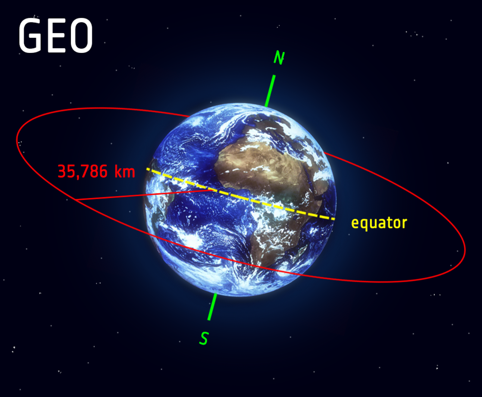
- Geostationary Orbit: This is a high Earth orbit that allows satellites to match Earth's rotation. Located directly above the equator, these satellites appear stationary from any fixed point on Earth.
Geostationary orbit
Image Courtesy ESA
- Altitude: The specific altitude of approximately 35,786 kilometres is chosen because it allows the satellite's orbital period to synchronise with the Earth’s rotation.
- Orbital Period: A key feature is its orbital period of exactly 24 hours, which matches the Earth’s rotational period, causing it to hover over the same spot.
Synchronous Rotation and Coverage
- Synchronous Rotation: This attribute is critical for constant, uninterrupted service in various applications like communications and broadcasting.
- Coverage Area: A geostationary satellite covers approximately one-third of the Earth's surface, providing significant coverage for communication and meteorological observation.
Conditions for Geostationary Orbits
Orbital Mechanics and Speed
- Precise Orbit: The orbit must be a perfect circle; any elliptical shape would result in a varying speed and position relative to Earth.
- Specific Speed: The satellite must maintain a speed that ensures its orbital period matches the Earth's rotation. This speed is a delicate balance between gravitational pull and the centrifugal force from its motion.
Equatorial and Stability Requirements
- Equatorial Alignment: The orbit must lie in the Earth’s equatorial plane. Any deviation would result in an apparent north-south motion of the satellite as seen from Earth.
- Stability: Achieving and maintaining this orbit requires careful management of various forces and periodic adjustments to counterbalance any perturbations like solar wind or gravitational influences from celestial bodies.
Applications and Importance
Communication and Broadcasting
- Communication Networks: Geostationary satellites are fundamental in long-distance communication networks, including telephone, internet, and live broadcasting.
- Constant Coverage: Their fixed position enables consistent coverage, making them ideal for television and radio broadcasting that requires uninterrupted signal transmission.
Weather Monitoring and Analysis
- Continuous Observation: These satellites can continuously observe weather patterns over a particular region, crucial for early warning systems for natural disasters.
- Climate Research: They also play a significant role in long-term climate research and monitoring, contributing valuable data for environmental studies.
Challenges in Geostationary Orbits
Congestion and Signal Interference
- Limited Slots: The desirable traits of geostationary orbits mean they are highly sought after, leading to congestion in this orbital 'belt.'
- Interference: The proximity of satellites can lead to signal interference, necessitating international agreements and regulations to manage orbital slots.
Geographical Limitations
- High-Latitude Limitations: These satellites are less effective for high-latitude regions due to the curvature of the Earth, which can hinder signal strength and line-of-sight communication.
Technological Demands
- Advanced Technology Requirements: Establishing and maintaining a satellite in a geostationary orbit requires sophisticated technology and precise engineering.
- Operational Challenges: Continuous adjustments are needed to counteract gravitational perturbations and to mitigate the effects of space debris.
Conclusion
The study of geostationary orbits offers an extensive understanding of the balance of forces in space and the precision needed in satellite communications. For students, it represents not only a crucial topic in physics but also a window into the technologies that underpin much of our modern communication infrastructure. Understanding these principles is vital for future advancements in space technology and communication systems.
Practice Questions
To determine the height, we need to equate the gravitational force to the centripetal force required for a geostationary orbit. The formula for gravitational force is F = Gm1m2/r², and for centripetal force, it is F = mv²/r, where v is the orbital velocity and r is the distance from the centre of the Earth. For a geostationary orbit, the orbital period (T) is the same as the Earth’s rotational period, which is 24 hours or 86400 seconds. We use v = 2πr/T to find the orbital velocity. Solving these equations, we find that the radius r from the Earth's centre is approximately 42,164 km. Subtracting the Earth's radius (about 6,371 km) gives us the height above the Earth's surface, approximately 35,793 km.
Equatorial alignment is critical for a geostationary satellite to remain fixed in position relative to a point on the Earth's surface. This alignment is essential for consistent communication and broadcasting, allowing for a constant signal reception area. If the satellite's orbit deviates from the equatorial plane, it would appear to oscillate north and south over a day. This movement would lead to signal loss or require ground receivers to track the satellite's motion, disrupting communication services. Therefore, precise equatorial alignment is vital for the efficient operation of geostationary satellites, ensuring uninterrupted data transmission and stable communication services.
FAQ
Geostationary orbits are not suitable for polar coverage due to their equatorial alignment. These satellites orbit above the Earth's equator and have a fixed position relative to the Earth's surface, providing coverage primarily to equatorial and mid-latitude regions. For regions near the poles, the curvature of the Earth and the angle of the satellite's position result in weak or no signal reception. This limitation makes geostationary satellites ineffective for direct communication or observation at high latitudes. Instead, polar regions are better served by polar-orbiting satellites, which move over the poles and can provide comprehensive coverage of these areas.
The geostationary satellite 'belt' refers to the ring around the Earth where satellites can maintain a geostationary orbit. This belt is significant due to its limited capacity and strategic importance for communication and broadcasting. As the number of satellites in this belt has increased, managing this space has become crucial to avoid signal interference and collisions. International organisations, like the International Telecommunication Union (ITU), allocate slots in this belt to different countries and companies, ensuring organised and fair use. This management includes coordinating orbital positions and frequencies to minimise interference, maintaining safe distances between satellites, and ensuring efficient use of this valuable orbital space.
Placing a satellite into a geostationary orbit involves several stages, starting with a launch into an initial parking orbit, typically a low Earth orbit (LEO). From this parking orbit, the satellite is manoeuvred to a geostationary transfer orbit (GTO) using its onboard propulsion system. This transfer orbit is an elliptical orbit with one point close to Earth (perigee) and the other near the geostationary orbit's altitude (apogee). When the satellite reaches the apogee, it performs another burn to circularise the orbit at the geostationary altitude. Precision in these manoeuvres is crucial to achieving the correct altitude, orbital period, and equatorial alignment necessary for a geostationary orbit.
Geostationary satellites are equipped with solar panels that harness solar energy, the primary power source for these satellites. These solar panels are large and efficient, designed to capture as much sunlight as possible. The satellite's position in a geostationary orbit ensures consistent exposure to sunlight, except during brief periods of eclipse around the equinoxes. Additionally, satellites have batteries that store energy, providing power during eclipses or periods of reduced solar exposure. The combination of advanced solar technology and battery storage allows these satellites to operate continuously for extended periods, often spanning several years, sometimes more than a decade, before requiring replacement or significant maintenance.
A geostationary orbit's constant altitude is a result of the need to balance gravitational force and the centripetal force for a satellite to remain stationary over a point on the Earth's surface. This specific altitude, approximately 35,786 kilometers, is where a satellite's orbital period synchronises with the Earth's rotation period of 24 hours. At this altitude, the gravitational pull of the Earth and the required orbital velocity create a perfect balance, allowing the satellite to maintain a fixed position in the sky relative to an observer on Earth. Any deviation from this altitude would alter the balance, resulting in a different orbital period that would not match the Earth's rotation, hence the satellite would not appear geostationary.
