
Cloud Formation
Clouds are central to the understanding of precipitation, formed by the condensation of water vapour in the atmosphere. The classification of clouds is based on their appearance and altitude, influencing the type of precipitation.
- Cumulus: Characteristically fluffy, white clouds with flat bases, indicating stable weather. These clouds form due to the rising and cooling of moist air.
- Stratus: Uniform grey clouds covering the sky, often associated with continuous light rain or drizzle. They are typical in stable weather conditions.
- Cirrus: Thin, wispy clouds found at high altitudes. Formed from ice crystals, they often indicate a change in weather, such as an approaching front.
- Nimbus: Dense and dark, these clouds are laden with moisture and are commonly linked with heavy and continuous precipitation.
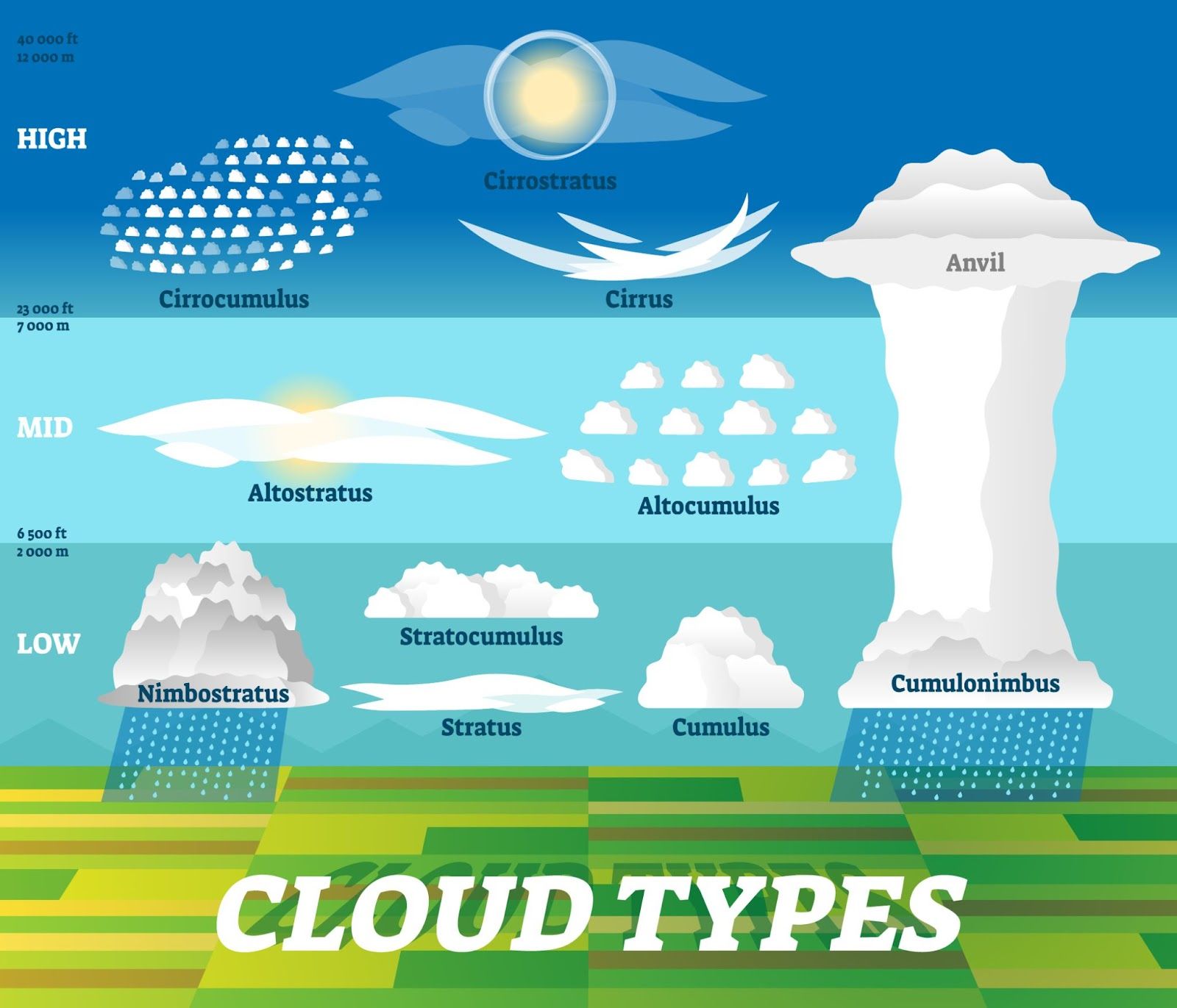
Image courtesy of VectorMine
Relationship to Weather Events
The type of cloud present in the sky is a key indicator of impending weather events. For example, the development of cumulonimbus clouds, a type of cumulus cloud, is often a precursor to thunderstorms and heavy rainfall.
Rain
As the most common form of precipitation, rain significantly impacts the environment, agriculture, and water resources.
Mechanisms of Raindrop Formation
Two primary processes lead to the formation of raindrops:
- Coalescence Process: Involves the merging of smaller water droplets in warm clouds to form larger raindrops.
- Bergeron-Findeisen Process: This process occurs in colder clouds where ice crystals grow at the expense of water droplets and fall as rain upon melting.
Types of Rain
- Frontal Rain: Associated with frontal systems, where different air masses meet, causing the warmer air to rise over the colder air.
- Orographic Rain: Results from moist air being forced to rise over mountainous terrain, cooling and condensing to form rain.
- Convectional Rain: Triggered by the heating of the Earth's surface, leading to rising air currents that cool and condense to form rain.
Hail
Hail is a form of solid precipitation, often causing damage to crops, property, and vehicles.
Conditions for Hail Formation
Hail formation requires:
- Strong Updrafts in Thunderstorms: These updrafts carry water droplets to heights where temperatures are below freezing.
- Supercooled Water Droplets: These droplets freeze upon contact with ice nuclei, forming hailstones.
Hailstorm Dynamics
Hailstorms are characterized by:
- Rapid Formation: Hailstones form quickly within strong thunderstorms.
- Varying Sizes: Hailstones can vary in size, from small pellets to large, golf-ball-sized stones.
Snow
Snow, a form of precipitation that occurs in cold conditions, has significant implications for ecosystems, water resources, and human activities.
Snowflake Formation
- Sublimation: Direct transformation of water vapour into ice crystals.
- Temperature and Humidity: These factors determine the shape and size of snowflakes, with different temperatures and humidity levels producing various crystal structures.
Factors Influencing Snowfall
- Air Temperature: Determines whether precipitation falls as snow or rain.
- Geographic Location: Areas closer to the poles or at higher altitudes are more likely to experience snow.
Dew and Fog
Dew and fog are forms of condensation, crucial in understanding local weather phenomena.
Formation Conditions
- Dew: Forms when objects on the ground cool below the dew point temperature, causing water vapour in the air to condense.
- Fog: Arises when the air near the ground is cooled to its dew point, leading to the condensation of water vapour.
Types of Fog
- Radiation Fog: Develops under clear skies and calm winds, primarily at night.
- Advection Fog: Occurs when warm, moist air moves over a cooler surface, cooling the air to its dew point.
Environmental Impacts
- Visibility: Both dew and fog can dramatically reduce visibility, affecting transportation.
- Agriculture: Dew provides essential moisture for plants, especially in arid regions.
Practice Questions
Hail formation is a complex process that occurs within strong thunderstorm clouds. It requires specific atmospheric conditions, primarily strong updrafts. These updrafts lift water droplets to heights where temperatures are below freezing, leading to the formation of hailstones. Supercooled water droplets in the cloud freeze upon contact with ice nuclei, creating hailstones. As they are carried up and down by the updrafts and downdrafts within the cloud, they accumulate layers of ice, growing in size. The hailstones eventually become too heavy to be supported by the updraft and fall to the ground. For a hailstorm to occur, a combination of high humidity, strong updrafts, and the presence of a cold upper atmosphere are necessary. These conditions typically align in severe thunderstorms, where hail can cause significant damage to crops, property, and vehicles.
Fog is a type of low-lying cloud that forms when air is cooled to its dew point, leading to the condensation of water vapour. The two main types of fog are radiation fog and advection fog. Radiation fog develops under clear skies and calm conditions, typically at night. It forms when the ground cools rapidly, lowering the air temperature near the ground to the dew point. Advection fog occurs when warm, moist air moves over a cooler surface, such as a cold ocean current or landmass, cooling the air to its dew point. The environmental impact of fog includes reduced visibility, which can affect transportation, especially aviation and road travel. In agriculture, fog can be beneficial as it provides essential moisture to plants, especially in arid regions. However, persistent fog can also lead to colder temperatures and reduced sunlight, which can affect crop growth.
FAQ
Different types of rain - frontal, orographic, and convectional - can indeed occur simultaneously, especially in regions where geographical and atmospheric conditions allow for their convergence. For instance, in a coastal area near mountains, orographic and frontal rain can occur together. Orographic rain might be triggered as moist air from the ocean is lifted over the mountains, while frontal rain could happen if a weather front is passing over the region at the same time.
Similarly, convectional rain, which results from localized heating of the Earth's surface, can occur in conjunction with frontal rain if the conditions are right. For example, during a warm front passage, the overall atmospheric instability can increase, leading to localized convectional showers in the warm sector of the front. These instances, while complex, demonstrate the dynamic nature of weather systems and the interplay of different meteorological phenomena to produce varied precipitation patterns.
Ice nuclei are particles in the atmosphere that facilitate the formation of ice crystals in clouds, playing a crucial role in cloud formation and precipitation, especially in colder cloud environments. These nuclei can be any small particle, like dust, pollen, or even certain types of bacteria, that has properties allowing water vapour to deposit directly as ice. This is a process known as deposition, which is critical in the formation of ice crystals in clouds at temperatures below freezing.
In the Bergeron-Findeisen process, ice nuclei are essential as they provide the initial platform for ice crystal formation in supercooled clouds. The presence of these ice crystals leads to a process where water vapour is deposited onto the ice crystals, causing them to grow at the expense of the surrounding supercooled water droplets. This growth is key to the development of precipitation, as the ice crystals eventually become large enough to fall to the ground, melting into raindrops if the lower atmosphere is warm enough. Without ice nuclei, the formation of precipitation in cold clouds would be significantly less efficient.
The intensity and frequency of hailstorms are influenced by several atmospheric and environmental factors. Key among these is the presence of strong updrafts within thunderclouds, which are essential for sustaining hailstone formation. The strength and persistence of these updrafts determine how long hailstones can circulate within the cloud, growing in size before falling to the ground. The temperature profile of the atmosphere also plays a crucial role. Cooler temperatures at higher altitudes promote the formation of hail, as they allow for the maintenance of supercooled water droplets and ice nuclei.
Additionally, the amount of moisture present in the atmosphere can affect hailstone formation. More moisture provides more material for hailstones to grow. The geographical location and topography also influence hailstorm occurrences. Regions prone to severe thunderstorms, particularly those in mid-latitudes where cold and warm air masses frequently collide, are more likely to experience hail. Mountainous regions can also enhance the conditions necessary for hail formation due to the orographic lifting of air masses. Understanding these factors is important for predicting hailstorm events and preparing for their potential impacts.
The Bergeron-Findeisen process and the coalescence process are two distinct mechanisms for rain formation, each occurring under different atmospheric conditions. The Bergeron-Findeisen process is predominant in cold clouds, typically those at higher altitudes or latitudes. It involves ice crystals in a supercooled cloud (a cloud containing water droplets below freezing temperature) growing at the expense of surrounding water droplets. The ice crystals, once large enough, fall and melt into raindrops if they pass through warmer air. This process is significant in producing precipitation from nimbostratus and cumulonimbus clouds.
On the other hand, the coalescence process, also known as collision and coalescence, is common in warm clouds. Here, cloud droplets merge during collisions, which occur more frequently in turbulent clouds. Larger droplets form and fall due to their increased weight. This process is dominant in tropical regions and during the summer in temperate zones, contributing significantly to rainfall from cumulus and cumulonimbus clouds. Understanding these two processes is crucial for meteorologists in predicting rainfall patterns and intensities in different climatic regions.
Meteorologists predict fog formation by analyzing various atmospheric conditions, including temperature, humidity, wind patterns, and topography. The prediction starts with identifying areas where the temperature is likely to fall to the dew point – the temperature at which air becomes saturated and water vapour condenses to form fog. Instruments like satellites, weather balloons, and ground-based sensors provide data on these variables.
Forecasters also look for conditions conducive to either radiation or advection fog. For radiation fog, clear skies and calm winds are key indicators, especially at night and early morning when the ground cools rapidly. In the case of advection fog, meteorologists monitor weather patterns that might bring warm, moist air over cooler surfaces, such as sea currents or snow-covered ground.
Predicting the potential impacts of fog involves understanding its duration, density, and area of coverage. Dense fog can significantly reduce visibility, affecting road and air travel. Forecasters issue warnings and advisories based on expected visibility levels and the duration of the fog event. They also assess the likelihood of fog lifting or persisting based on expected changes in weather conditions, such as rising temperatures or incoming wind systems.
In summary, fog prediction is a complex process that requires careful analysis of various atmospheric factors. Accurate predictions are crucial for public safety and transportation planning, helping to mitigate the risks associated with reduced visibility.
