
Convectional Precipitation
Mechanism
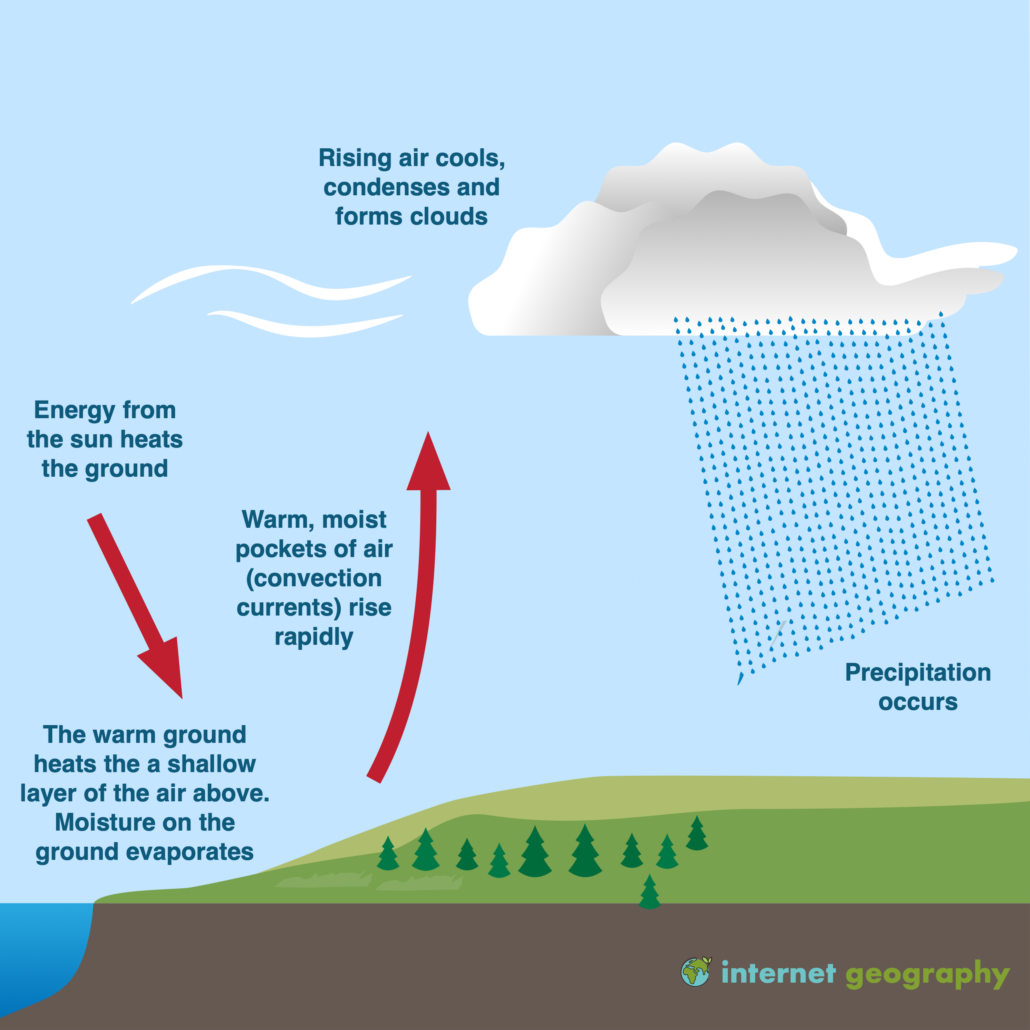
Convectional precipitation is a process predominantly seen in tropical regions but can occur anywhere where the ground sufficiently heats the air above it. The mechanism begins with the sun warming the Earth's surface. This heat is then transferred to the air directly above the surface. As air warms, it becomes less dense and begins to rise. During its ascent, the air cools adiabatically (without heat exchange), and its capacity to hold moisture decreases, leading to condensation when the air reaches its dew point. The result is the formation of cumulus clouds, which can further develop into cumulonimbus clouds if conditions allow.
Associated Weather Patterns
- Cloud Formation: The initial stages are marked by the appearance of puffy, white cumulus clouds that progressively grow larger.
- Thunderstorms and Rainfall: These clouds can develop into thunderstorms, characterised by intense, heavy rainfall over a small area for a short duration.
- Localised Impact: Convectional precipitation is often localised and can lead to significant variations in rainfall over short distances.
- Heat and Humidity: This type of precipitation is more common in regions with high temperatures and humidity levels.

Image courtesy of internetgeography.net
Frontal Uplift
Warm and Cold Fronts
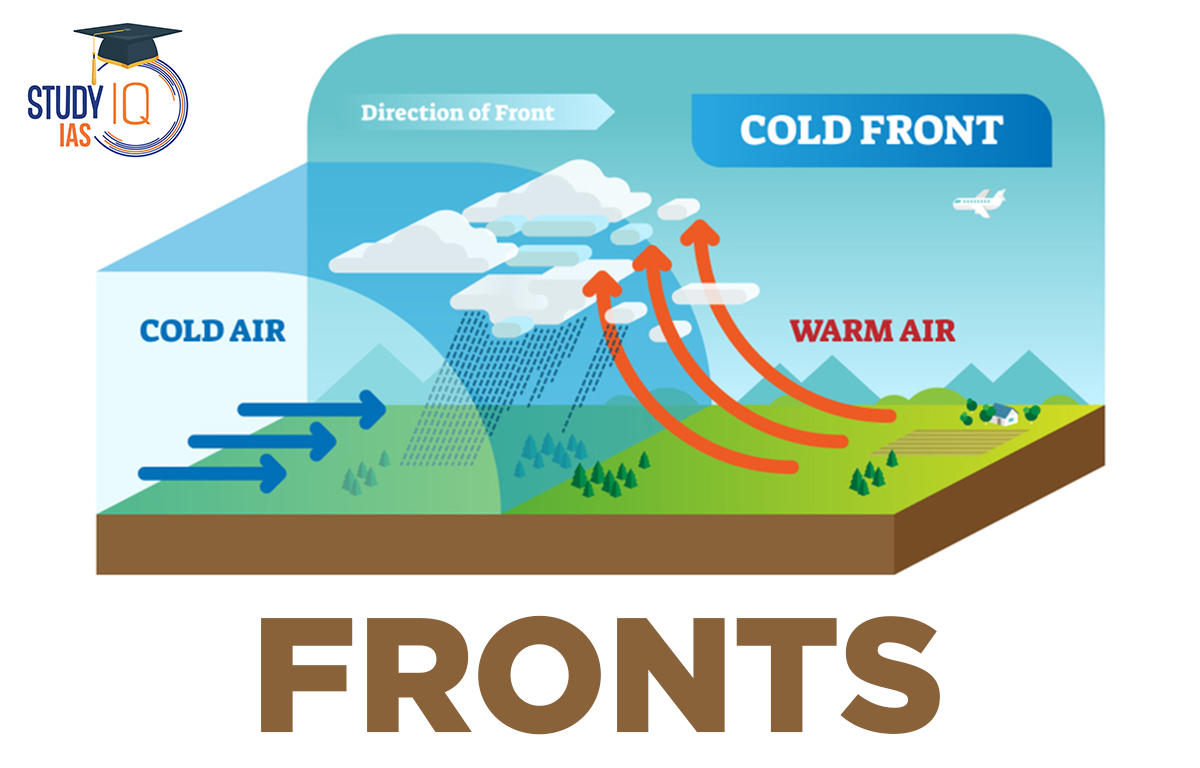
Frontal uplift occurs at the boundaries where two different air masses meet, typically a warm air mass and a cold air mass. The interaction between these air masses forms either a warm front or a cold front.
- Warm Fronts: Here, a warm air mass slides over a cold air mass. As the warm air is lifted, it cools down, leading to widespread cloud formation and prolonged, steady precipitation. The clouds formed are usually stratus and nimbostratus, covering large areas and leading to light to moderate rainfall.
- Cold Fronts: In contrast, a cold front forms when a colder air mass pushes beneath a warmer air mass, forcing the warm air to rise rapidly. This rapid ascent can cause the formation of cumulonimbus clouds, resulting in short, intense periods of rainfall, often accompanied by thunderstorms.
Resultant Precipitation Patterns
- Spatial and Temporal Distribution: Frontal precipitation is typically widespread, affecting large regions and can last for several days as the front slowly moves.
- Variability: The intensity and duration of precipitation vary depending on the strength of the front and the moisture content in the air masses involved.

Image courtesy of studyiq.com
Orographic Uplift
Impact of Topography
Orographic uplift is a significant precipitation mechanism in mountainous regions. When moist air is forced to ascend over a mountain range, it expands and cools, leading to condensation and precipitation.
Rain Shadow Effect
- Windward Side: The side of the mountain where the wind ascends receives significant rainfall, often characterised by lush, green vegetation.
- Leeward Side: Conversely, the leeward side, where the air descends, becomes warmer and drier, often resulting in semi-arid or arid conditions. This is known as the rain shadow effect.
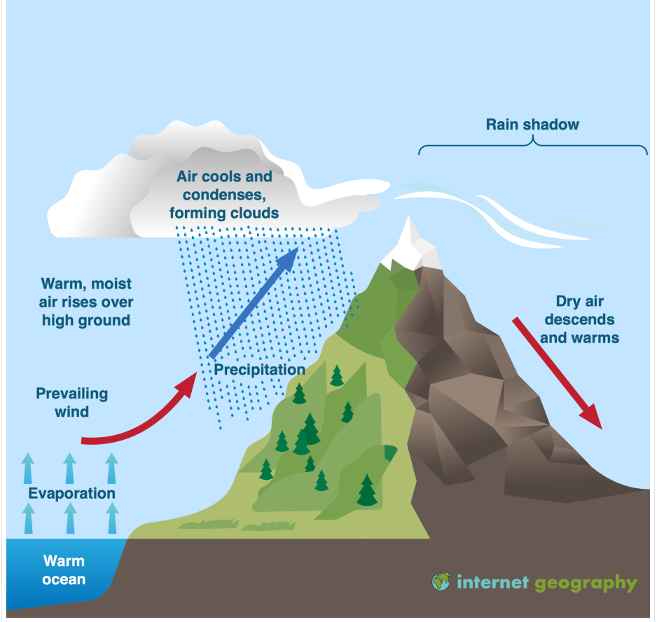
Image courtesy of internetgeography.net
Radiation Cooling
Night-time Cooling
This phenomenon is most pronounced during clear, calm nights. The Earth's surface, which absorbs heat during the day, radiates this heat back into space at night. This leads to a cooling effect, particularly near the ground.
Impact on Dew and Frost Formation
- Dew: Dew forms when the air near the ground cools to a point where it can no longer hold all its moisture, causing water vapour to condense on cool surfaces.
- Frost: Frost occurs under similar conditions but when the temperature falls below freezing. The water vapour sublimates (changes directly from gas to solid) forming ice crystals.
FAQ
The rain shadow effect can lead to significant environmental impacts. On the windward side of a mountain, where orographic uplift causes heavy precipitation, ecosystems are often lush and rich in biodiversity due to the abundant moisture. Forests in these areas are typically dense and can play a crucial role in carbon sequestration. In contrast, the leeward side, which receives little to no rainfall, often experiences arid conditions. This can lead to the development of deserts or semi-arid environments. The lack of moisture impacts soil quality, reducing its fertility and leading to challenges in vegetation growth. This stark contrast in ecosystems on either side of a mountain range can affect local climate, biodiversity, and human activities, with the drier side often facing challenges in agriculture and water scarcity.
Altitude plays a critical role in convectional precipitation. As altitude increases, the air becomes cooler and can hold less moisture. This means that highland areas can experience more frequent convectional precipitation due to the air reaching its dew point more quickly as it rises and cools. Additionally, in mountainous regions, the terrain can enhance the lifting and cooling of air, further promoting cloud formation and precipitation. However, the intensity of the precipitation might decrease with increasing altitude beyond a certain point, as the air becomes too cold and dry to support heavy rainfall. This altitude-dependent variation in convectional precipitation is crucial for understanding the distribution of rainfall in mountainous regions and its impact on local climates and ecosystems.
Condensation nuclei are minute particles in the atmosphere, such as dust, pollen, smoke, and salt from ocean spray, which play a vital role in condensation and cloud formation. Water vapour in the atmosphere requires a surface to condense upon, and these nuclei provide that surface. Without condensation nuclei, water vapour would remain in a gaseous state even at temperatures below the dew point, significantly inhibiting cloud formation. The presence of these particles facilitates the transformation of water vapour into tiny droplets, leading to the development of clouds. This process is crucial for both the water cycle and weather patterns. Additionally, the type and quantity of condensation nuclei can influence cloud properties, such as cloud thickness, longevity, and the likelihood of precipitation.
Local geographical features can significantly influence convectional precipitation patterns. Features such as lakes, rivers, and urban areas can enhance convectional precipitation due to their impact on local temperature and humidity levels. Bodies of water tend to heat up and cool down more slowly than land, which can lead to differences in air temperature and pressure, thereby affecting air circulation. Urban areas, known for their heat island effect, can also increase local temperatures, leading to greater instability and uplift of air. Terrain features, like valleys and plains, can direct the flow of air and potentially enhance upward motion, further contributing to cloud formation and precipitation. These local influences are crucial in determining the distribution, intensity, and frequency of convectional rainfall in a given area. For instance, a city located near a large body of water may experience more frequent afternoon thunderstorms in summer due to the combined effects of urban heating and moisture from the water. Similarly, valleys aligned with prevailing winds can channel moist air, enhancing convection and precipitation. Understanding these local geographic influences is essential for accurate weather prediction and for managing water resources and agricultural practices in these regions.
The diurnal cycle significantly influences convectional precipitation patterns. During the day, the sun heats the Earth's surface, which in turn warms the air above it. This warm air, rich in moisture, rises and cools, leading to the formation of clouds. In the late afternoon or early evening, these conditions often culminate in convectional precipitation. This timing is due to the peak surface temperatures typically reached in the afternoon, providing the necessary energy for air to rise. The intensity of this precipitation can vary but is generally short-lived, though it can be quite heavy, especially in tropical regions where the combination of heat and humidity is ideal for thunderstorm development. This cycle results in a distinct pattern of clear mornings followed by potential thunderstorms or showers in the afternoon or evening.
Practice Questions
Orographic uplift occurs when moist air masses are forced to ascend over mountain ranges. As the air rises, it cools and expands, leading to the condensation of water vapour and the formation of clouds. This process results in precipitation, predominantly on the windward side of the mountain. The rain shadow effect is observed on the leeward side, where the descending air warms and becomes drier, reducing the likelihood of precipitation. This leads to distinct climatic differences on either side of the mountain, with the windward side receiving more rainfall and the leeward side being comparatively drier, often resulting in arid conditions.
In a warm front, a warmer air mass gradually replaces a colder air mass. This leads to the slow ascent of warm air, cooling and forming wide, blanket-like stratus clouds. The precipitation from a warm front is typically light to moderate, steady, and spread over a large area, lasting for a longer duration. Conversely, in a cold front, a colder air mass aggressively slides under a warmer air mass, causing the warm air to rise rapidly. This results in the formation of cumulonimbus clouds and brings about short, intense periods of precipitation, often accompanied by thunderstorms. The precipitation is more localized and of shorter duration compared to a warm front.
