
Meanders
Meanders are a hallmark of mature river landscapes, characterized by their winding curves.
- Formation: The genesis of meanders lies in the natural tendency of water to flow in a non-linear path due to initial minor irregularities in the riverbed. Erosion intensifies on the outer banks, where water velocity is higher, leading to river cliffs. Conversely, slower water on the inner banks results in sediment deposition, forming point bars.
- Evolution into Oxbow Lakes: As meanders evolve, their bends can become extremely exaggerated. Flood events can expedite the formation of a new, straighter river course, leaving the meander loop isolated as an oxbow lake, a classic example of fluvial geomorphological change.
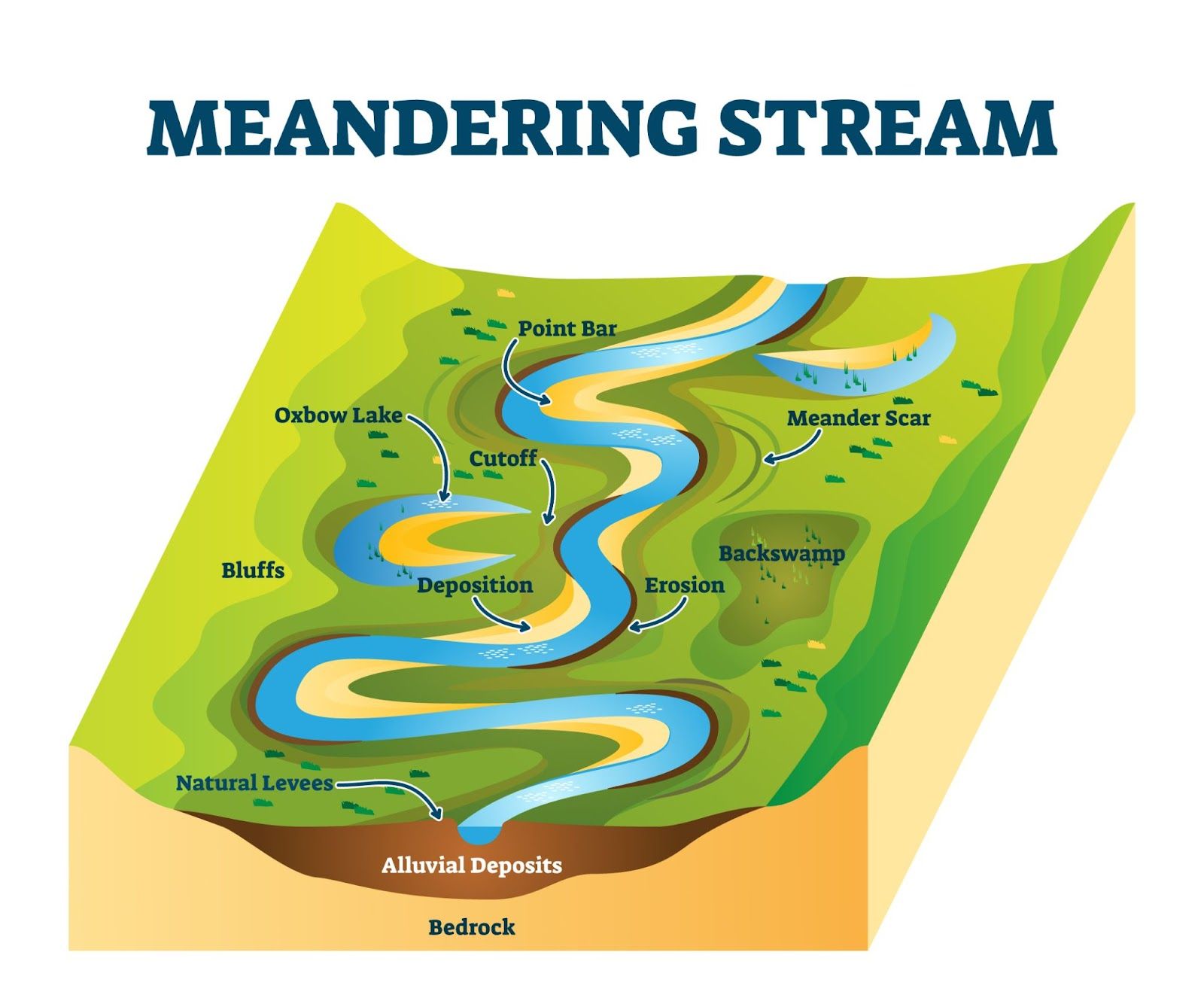
Image courtesy of VectorMine
Riffle and Pool Sequences
Riffles and pools are alternating shallow and deep areas within a river channel, critical for aquatic ecosystems.
- Formation: Riffles, with their shallow, rapid water over coarse substrate, form due to the accumulation of larger sediment particles. Pools, deeper and slower-moving, occur where finer materials settle.
- Hydrological Significance: These sequences regulate the flow and oxygenation of water, supporting diverse aquatic life. They also influence the navigability and sediment transport of the river.
Waterfalls and Gorges
These dramatic features illustrate the power of water over geologic time.
- Formation Processes: Waterfalls often emerge where a river encounters resistant rock strata overlaying softer rocks. Erosion eventually undercuts the harder rock, creating a vertical drop. Continued erosion at this drop can lead to the development of gorges, deep valleys with steep, rocky walls.
- Case Studies: The Victoria Falls on the Zambezi River and the Yosemite Valley in the USA are prime examples of these processes at work.
Bluffs
Bluffs are steep banks or cliffs along river valleys, formed through erosion and land movements.
- Erosional Features: The river's lateral erosion undercuts the valley sides, leading to the collapse of overlying material and the formation of bluffs.
- Formation and Stability: Factors like soil type, moisture content, vegetation, and human activity influence their formation and stability. Unstable bluffs can lead to landslides, significantly altering the river landscape.
Floodplains
Floodplains are extensive, flat lands adjacent to rivers, shaped by floodwaters.
- Development: Over time, floodwaters deposit layers of alluvium, creating fertile plains. This sedimentation process can be observed after major flood events.
- Features like Levées: Levées are natural embankments along rivers, formed by the deposition of coarser sediments during floods. They are highest closest to the river, tapering away into the floodplain.
- Ecological Importance: They are vital for flood management, agriculture, and habitat diversity. The nutrient-rich soils support diverse ecosystems and are often utilized for farming.
Deltas
Deltas form at the mouths of rivers, where they disperse their sediment into a standing body of water.
- Types: Deltas vary in shape and structure, depending on factors like sediment load, wave action, and tidal range. The Nile Delta, for example, is a classic arcuate delta, while the Mississippi Delta is a bird's foot type.
- Formation Processes: The slowing of river velocity upon meeting a larger body of water causes sediment to settle out. Over time, this accumulation of sediment forms the delta, often creating a rich mosaic of channels and landforms.
- Sediment Distribution: The pattern of sediment distribution in a delta is complex, influenced by the river's flow, the nature of the sediments, and the dynamics of the receiving water body. Fine sediments typically travel further, while coarser materials settle near the river mouth.
FAQ
The presence of waterfalls and gorges can indeed be indicative of past climatic conditions. Waterfalls often form in areas where there is a sudden change in bedrock hardness, a feature that can be related to past geological and climatic events. For instance, a period of glaciation might have left behind varying layers of rock, leading to the formation of waterfalls as rivers flow over these layers. Similarly, the formation of gorges is heavily influenced by the volume and speed of water flow, which are in turn affected by historical rainfall patterns and glacial meltwater. Analyzing the size, shape, and erosion patterns of gorges can provide insights into historical climatic conditions, such as periods of heavy rainfall or drought, that would have influenced the river's erosive power.
Changes in river discharge and sediment load significantly affect the development of floodplains. A higher river discharge, often due to heavy rainfall or snowmelt, leads to flooding, where the river overflows its banks and spreads over the adjacent land. During these flood events, sediment carried by the river is deposited across the floodplain. A greater sediment load increases the thickness of these deposits, gradually raising the level of the floodplain. Conversely, a decrease in discharge or sediment load can slow down floodplain development. Additionally, variations in sediment size and type influence the soil characteristics of the floodplain. Fine sediments create fertile soils, while coarser materials may lead to more uneven surfaces. Human activities such as damming can also alter discharge and sediment load, impacting the natural process of floodplain formation.
Riffle and pool sequences play a crucial role in river restoration and management projects. These natural features enhance the ecological health of a river by providing diverse habitats for aquatic organisms. Riffles, with their shallow, oxygen-rich waters, support species like fish and macroinvertebrates, while pools offer deeper, slower-moving water beneficial for different aquatic life. In river restoration, recreating or enhancing riffle and pool sequences can improve biodiversity, water quality, and habitat complexity. This approach is essential in urban or modified rivers, where natural features may have been lost. Additionally, these sequences play a role in sediment management. Riffles help to trap and sort sediments, while pools allow for the settlement of finer materials. This natural sediment regulation is crucial for maintaining river channel stability and preventing excessive erosion or siltation. Furthermore, riffle and pool sequences contribute to the aesthetic and recreational value of rivers, making them more attractive for activities like fishing and kayaking. Therefore, incorporating these features in river management projects is vital for ecological restoration, biodiversity conservation, and enhancing the recreational and aesthetic value of riverine environments.
Youthful and mature river landforms exhibit distinct characteristics, shaped by the stage of the river's course. In youthful rivers, features such as V-shaped valleys, waterfalls, and rapids are prevalent. These rivers are typically found in upper courses where gradients are steep and erosion is dominant. In contrast, mature rivers, typically found in the middle to lower course, show features like wider valleys, floodplains, meanders, and deltas. The formation of meanders in mature rivers is due to the increased load and decreased gradient, causing lateral erosion and deposition. Deltas form in mature stages where rivers meet larger bodies of water, depositing their sediment load. The key difference lies in the erosion and deposition processes; youthful rivers are more erosive, carving out landscapes, while mature rivers are more depositional, shaping landforms like meanders and deltas.
Human activities significantly impact the formation and evolution of meanders. Activities like deforestation, urbanization, and agriculture can alter the natural flow of a river, affecting its ability to meander. Deforestation, for instance, leads to increased sediment in rivers due to soil erosion. This can accelerate the meandering process as more sediment is available for deposition on the inner banks. Urbanization and the construction of levees or dams disrupt the natural flow, potentially hindering the formation of new meanders or even straightening existing ones. Furthermore, agriculture along riverbanks can lead to increased erosion due to the removal of vegetation, altering the river's course and the development of meanders. These human-induced changes can have significant ecological consequences, affecting habitats and biodiversity within river ecosystems.
Practice Questions
Meanders form due to the lateral erosion and deposition processes in a river. Water flows faster on the outside of bends, causing erosion and forming river cliffs. In contrast, on the inside of bends where the flow is slower, sediment is deposited, creating point bars. This erosion and deposition gradually accentuate the river bends, leading to the formation of meanders. Meanders are significant as they illustrate the dynamic nature of river systems, showing how rivers change course over time. They also play a critical role in the development of river landscapes, influencing sediment transport and deposition patterns. The formation of meanders can have ecological implications, such as creating diverse habitats for wildlife.
A river delta forms when a river deposits its sediment load into a standing body of water, like a sea or lake. This occurs as the river slows down and loses its capacity to carry sediment. Over time, this sediment builds up, creating the delta. Deltas are ecologically important as they often host diverse ecosystems, including unique habitats for wildlife. They act as natural filters, trapping pollutants and improving water quality. Moreover, deltas are fertile areas ideal for agriculture and support a rich biodiversity. They also provide natural barriers against marine incursions, helping to protect inland areas from flooding and storm surges.
