
Velocity and Discharge
Measurements of Velocity and Discharge
- Velocity is a fundamental aspect of river dynamics. It refers to the speed at which water flows in a river, directly influencing erosion and sediment transport. It can be measured using various methods, including float techniques (timing a floating object over a set distance) or more advanced methods like acoustic Doppler current profilers.
- Discharge, quantifying the volume of water flowing past a point in the river per unit of time, typically in cubic metres per second (m³/s), is crucial for understanding the river's capacity to transport sediment and its potential for flooding. Discharge is calculated by multiplying the river's cross-sectional area by the water's velocity.
Controlling Factors
- Several factors influence velocity. The gradient or slope of the river bed is a primary factor; steeper slopes lead to faster water flow. The size and shape of the river channel also play a role; narrower or deeper channels can speed up the flow. Additionally, the roughness of the river bed, influenced by the size and distribution of sediments and obstacles, can slow down the water flow.
- Discharge is controlled by various environmental factors. Precipitation levels, including rain and snowmelt, significantly affect discharge. The size and characteristics of the watershed or catchment area, such as its vegetation cover, soil type, and land use, also influence how much water reaches the river.
Implications for River Processes
- High velocity enhances the river's capacity for erosion, particularly in its ability to dislodge and transport sediment. This leads to changes in the river channel and shapes the landscape through processes like the formation of gorges and valleys.
- Changes in discharge can have significant impacts. For instance, heavy rainfall or snowmelt can lead to high discharge levels, potentially causing flooding. Conversely, low discharge during dry periods can reduce a river's ability to transport sediment, affecting its ecology and usability for human activities like navigation and irrigation.
Flow Patterns
Laminar Flow
- In laminar flow, water moves in smooth, parallel layers with minimal mixing between them. This flow type is less common in natural rivers and is typically observed in slow-moving, shallow streams or at the edges of a river channel. Due to the reduced mixing of water layers, laminar flow is less capable of eroding and transporting sediment.
Turbulent Flow
- Turbulent flow is characterised by chaotic, swirling motions of water. This type of flow is common in fast-flowing, deep rivers. The increased mixing and energy associated with turbulent flow significantly enhance the river's capacity for erosion and sediment transport. This flow pattern is responsible for many of the dynamic changes seen in river channels and shapes the landscape in more dramatic ways than laminar flow.
Helicoidal Flow
- Helicoidal flow is a complex flow pattern that resembles a corkscrew or spiral motion. It is particularly evident in meandering rivers, where it plays a crucial role in the formation and maintenance of meanders. In this pattern, water spirals from the outer bend of the river (where it erodes the bank) down to the river bed and then up along the inner bend (where it deposits sediment). This continual process leads to the distinctive meandering pattern of such rivers, with erosion on the outer banks and deposition on the inner banks.
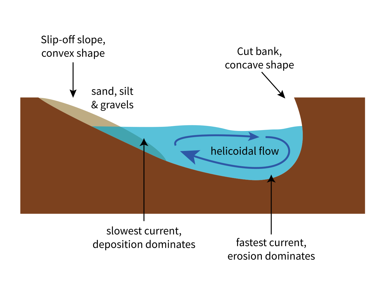
Image courtesy of en.wikipedia.org
Thalweg
Definition and Significance
- The thalweg is a term used to describe the deepest and fastest-flowing part of a river channel. It is often used in legal contexts to demarcate boundaries between territories.
- In terms of channel navigation, the thalweg is significant because it marks the most efficient path for water flow, and consequently, it is often the preferred route for navigation due to its depth and current.
- From a geomorphological perspective, the thalweg plays a critical role in the transport of sediment within the river. It is where the maximum energy of the river is concentrated, leading to more significant erosion and transport of materials. Over time, the location of the thalweg can shift, leading to changes in the river channel's morphology. These shifts are particularly important in meandering rivers, where the thalweg's position influences the development and eventual cutoff of meanders, forming oxbow lakes.
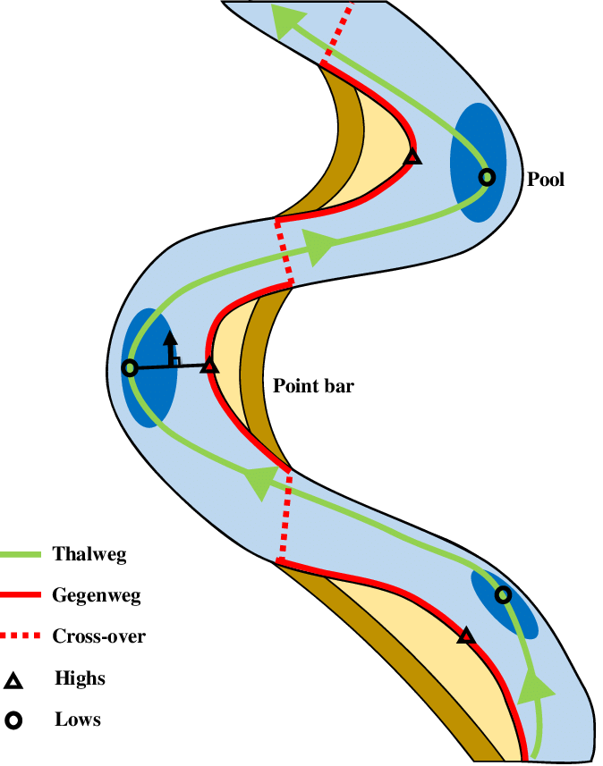
Image courtesy of researchgate.net
Role in Ecosystems and Human Activities
- Ecologically, the thalweg often harbors the deepest water, providing habitats for various aquatic species. It's a crucial zone for fish and other wildlife, especially in regions where water levels fluctuate.
- In human activities, understanding the thalweg is essential for river management, including navigation, bridge construction, and ecological conservation. It also has legal significance in defining boundaries for territorial waters in international rivers.
Integrated Understanding of River Flow
Understanding river flow, encompassing the concepts of velocity, discharge, flow patterns, and the thalweg, provides a comprehensive picture of how rivers interact with their environment. This knowledge is crucial for several reasons:
- Landscape Formation: Rivers are dynamic forces in shaping the landscape. The erosion and deposition driven by river flow create various landforms, from large valleys and canyons to intricate meander loops and deltas.
- Ecosystem Dynamics: Rivers are ecosystems in themselves and also influence surrounding terrestrial ecosystems. The flow patterns and the changing nature of rivers impact the distribution and abundance of species.
- Human Impact and Management: Understanding river flow is vital for effective river management. It aids in flood control, sustainable usage of water resources, and maintaining navigable channels. Also, in an era of climate change, where weather patterns are becoming more unpredictable, a thorough understanding of river flow dynamics is crucial for disaster preparedness and mitigation.
- Educational and Research Importance: For students and researchers in geography and environmental sciences, grasping these concepts is fundamental. It enables them to analyze and predict changes in river systems, contributing to broader environmental management and conservation efforts.
FAQ
River flow plays a crucial role in the formation and evolution of deltas and estuaries. In deltas, the decrease in river velocity upon meeting a larger body of water like an ocean or a sea causes the river to deposit its sediment load, forming a delta. The shape and size of a delta depend on the balance between sediment supply, river flow dynamics, and tidal and wave actions. In estuaries, the mixing of freshwater and saltwater creates unique environments. The river's flow influences sediment deposition patterns and salinity gradients, affecting the ecological characteristics of estuaries. Both deltas and estuaries are dynamic environments, highly sensitive to changes in river flow, which can be influenced by natural factors and human activities like dam construction and climate change. These areas are often rich in biodiversity and are crucial for fisheries, but they are also vulnerable to pollution and habitat destruction, making understanding and managing river flow essential for their conservation.
Seasonal variations can have a profound effect on river flow patterns. In temperate regions, rivers often experience higher discharge during spring due to snowmelt and rain, leading to increased velocity and potential flooding. Conversely, during summer and autumn, lower precipitation can result in reduced flow and velocity, affecting sediment transport and possibly leading to low water levels that hinder navigation and affect aquatic habitats. In tropical regions, monsoon seasons bring heavy rains, significantly increasing river discharge and velocity, often causing dramatic changes in river morphology through erosion and deposition. Dry seasons, on the other hand, can lead to decreased flow, impacting water availability for agriculture and domestic use. Understanding these seasonal dynamics is crucial for effective river management, particularly in the context of climate change, which can alter these patterns.
Flow velocity has a significant impact on river water quality. High flow velocities can lead to increased aeration of the water, which is beneficial for aquatic life as it enhances oxygen levels. However, this high velocity can also resuspend sediments from the river bed, which might contain pollutants, thus increasing water turbidity and potentially releasing harmful substances into the water column. On the other hand, low flow velocities can lead to a range of water quality issues. Stagnant or slow-moving water may experience reduced oxygen levels, affecting aquatic life. It can also lead to the accumulation of pollutants, as there is insufficient flow to dilute and disperse them. Additionally, slow-moving water can become a breeding ground for pathogens and algae, further degrading water quality. Therefore, maintaining an optimal flow velocity is crucial for sustaining good river water quality, which is essential for ecological health, human consumption, and recreational uses.
Managing river flow involves several methods, each serving different purposes like flood control, navigation enhancement, or ecological preservation. One common method is the construction of dams and reservoirs, which regulate the flow of water, controlling discharge and storing water for later use. However, dams can disrupt natural river ecosystems and sediment flow. Levees and flood walls are another method, designed to contain high water levels and prevent flooding of adjacent land. Channelization, which involves modifying the river channel, is used to improve navigation, increase flow velocity, or redirect the river for urban development. River restoration projects aim to return modified rivers to a more natural state, often to improve habitat quality and natural flow regimes. Each method impacts river flow and the surrounding ecosystem, highlighting the need for careful planning and consideration of environmental impacts.
Human activities can significantly impact river velocity and discharge. Urbanization, for instance, alters the landscape, increasing surface runoff and reducing natural water absorption, leading to higher discharge levels. This can result in increased river velocity, especially during heavy rainfall, heightening the risk of flooding. Conversely, damming and water diversion for irrigation or hydroelectric power can drastically reduce discharge downstream, slowing river velocity. This reduction can affect sediment transport, leading to sediment accumulation upstream and erosion downstream. Furthermore, land-use changes, like deforestation, can alter the water cycle, affecting both velocity and discharge. These changes not only impact the river's physical characteristics but also have ecological and socio-economic implications, such as altered habitats and affected water availability for communities and agriculture.
Practice Questions
Velocity in rivers is typically measured using float methods, where an object's travel time over a known distance is timed, or through advanced techniques like acoustic Doppler current profilers. Discharge, indicating the volume of water passing a point per time unit, is calculated by multiplying the river's cross-sectional area by its velocity. These measurements are critical in understanding river dynamics. High velocity increases erosion potential, reshaping the river landscape, while variations in discharge impact sediment transport, flooding, and ecological health. Accurate measurements are essential for effective river management and predicting environmental changes.
Laminar flow in rivers is characterised by smooth, parallel layers of water with minimal mixing, often found in slow-moving or shallow parts of a river. This flow type is less capable of eroding and transporting sediment due to its lower energy and reduced mixing. In contrast, turbulent flow features chaotic, swirling water motions, commonly observed in fast-flowing, deeper rivers. This increased energy and mixing in turbulent flow significantly enhance the river’s erosion and sediment transport capabilities, leading to more pronounced changes in river morphology, such as the formation of deeper channels and more varied bedforms compared to areas with laminar flow.
